BRADWELL s a quiet village, and has been
a special place from Roman times to today.
With peaceful walks and a smugglers' pub
just minutes away, you could not ask for a
more relaxing spot. Nearby St. Peters
Chapel is said to be the oldest church in
Essex.

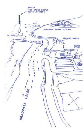
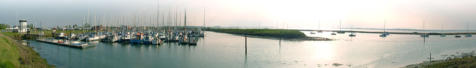
Craft approaching the seaward should leave the remains
of the ‘Baffles’ off Bradwell Nuclear Power Station to Port,
and the North Cardinal marking the spit at the northern
end of ‘Pewitt Island’ which shows a quick flashing white
light, and the ‘Tide Guage’ to starboard.
The Tide Guage shows the maximum depth in Bradwell
Creek in feet. There is no bar, the Creek being roughly
level from the Beacon to the Marina entrance.
The Creek is marked with red can to port and withies to
starboard. The deeper water is found centrally between
the cans and withies.
Triangular topped leading marks are in place on shore and
a green conical bouy. The deeper water after rounding this
is to the shore side of most boats, other than the small
sailing dinghies belonging to Bradwell Sailing Centre.
A listening watch is kept on VHF channel 80 08:30 -
17:00 every day. If you plan to visit us please call before
17:00 the day you plan to arrive.


© Bradwell Marina 2016
Craft approaching the seaward should leave the remains
of the ‘Baffles’ off Bradwell Nuclear Power Station to Port,
and the North Cardinal marking the spit at the northern
end of ‘Pewitt Island’ which shows a quick flashing white
light, and the ‘Tide Guage’ to starboard.
The Tide Guage shows the maximum depth in Bradwell
Creek in feet. There is no bar, the Creek being roughly
level from the Beacon to the Marina entrance.
The Creek is marked with red can to port and withies to
starboard. The deeper water is found centrally between
the cans and withies.
Triangular topped leading marks are in place on shore and
a green conical bouy. The deeper water after rounding this
is to the shore side of most boats, other than the small
sailing dinghies belonging to Bradwell Sailing Centre.
A listening watch is kept on VHF channel 80 08:30 -
17:00 every day. If you plan to visit us please call before
17:00 the day you plan to arrive.